Technical Portal for Sustainable Architecture

Advanced Diagnostics & Technical Monitoring
Non-destructive analysis and aerial surveys to prevent damage and optimize maintenance plans.
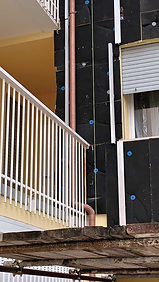
Thermographic Diagnostics
Thermographic surveys are more than just color maps; they're the primary tool for certifying the health of the building envelope. We use high-resolution thermal imaging cameras (via drone for roofs and facades, or on the ground for interiors) to identify critical issues before they lead to structural damage or unsustainable energy costs.
What we identify with pinpoint precision:
-
Thermal Bridges and Leaks: Analysis of construction joints and windows for effective energy efficiency.
-
Leaks and Hidden Moisture: Early detection of rising damp, interstitial condensation, and water infiltration before plaster peels off.
-
Predictive Diagnostics: Non-destructive interventions that allow for planned maintenance, eliminating the need for exploratory demolition.


Thermographic survey
The energy images detected by the thermal imaging camera are represented as color images. These represent the thermal mapping of the object's surface. This is why we can consider thermography a non-destructive tool.
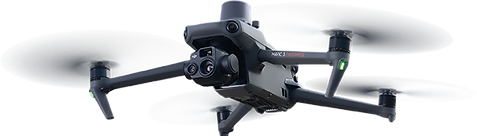
Aerial Surveys and Photogrammetry (SAPR)
Aerial surveying with UAV is our solution for mapping complex and difficult-to-access areas. It's not just a flight, but a data acquisition methodology that integrates traditional topographic surveys with the precision of 3D geospatial data.
Added value for the designer:
-
Speed and Safety: Immediate operation on slopes, roofs, infrastructure, or inaccessible areas, ensuring complete operator safety.
-
Integrable Geospatial Data: Production of orthomosaics, point clouds, and DTMs (Digital Terrain Models) compatible with BIM and CAD software, for design based on real data, not estimates.
-
Time Efficiency: Drastically reduce survey hours on site compared to traditional methods, with an incomparably higher information density (thousands of points versus just a few station points).

Drone surveys
Unmanned Aerial Systems (UAS) are increasingly high-performance and suitable for use in construction, surveying, and architecture. Thanks to sophisticated GPS navigation systems, they can fly with precision and perform numerous services, ensuring accurate and safe results.
Drone surveying offers enormous potential for GIS (Geographic Information System) professionals.
Topographic surveys can be performed with the same quality as highly accurate measurements collected using traditional methods, but in a fraction of the time. This substantially reduces the cost of a site survey and the workload of specialists in the field.
Advanced Diagnostics: Precision that Reduces Costs
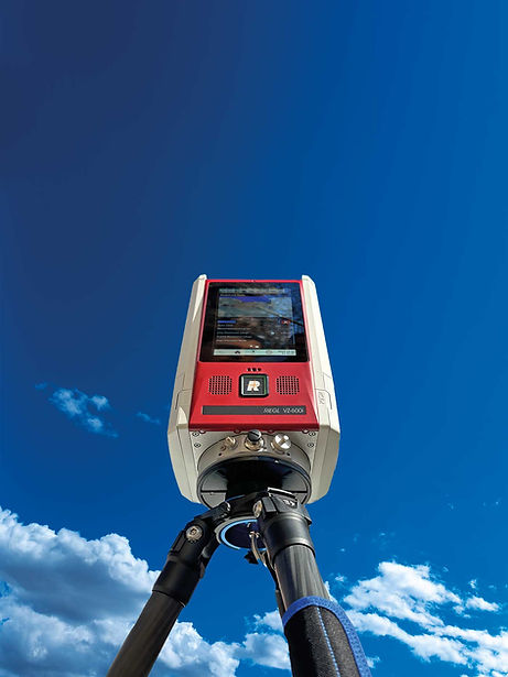
Surveying errors are the main cause of project changes and chronic delays. Our integrated diagnostics system uses LiDAR and SLAM acquisition technologies (Riegl VZ-600i and GeoSLAM ZEB Horizon RT) to transform any complex context, from monumental architecture to underground environments, into a millimeter-accurate digital model.
Benefits for your project:
-
Zero Interference: We identify structural issues and out-of-squareness before they become construction site problems.
-
Certified Georeferencing: Objective data on which to base the structural calculations of anchoring systems.
-
Operational Efficiency: Quick data acquisition even in the absence of a GPS signal (tunnels, tunnels, complex architecture).
Survey Engineering
We don't sell point clouds; we provide reliable design foundations. Our turnkey service guarantees:
-
3D and CAD rendering: Integrate surveyed data directly into modeling software, ready for building envelope engineering.
-
Real-time verification: Thanks to RT (Real-Time) technology, we validate the integrity of the survey while on site, eliminating the need for repeated inspections.
-
Context Analysis: Automatic classification of structures, networks, and vegetation for precise management of construction site areas.
The sky is the limit
Riegl VZ-600i Laser Scanner
-
Range: 1.000 m
-
Accuracy: 3 mm
-
Vegetation bypass: up to 31 echoes on the same beam
-
Automatic registration and georeferencing on board the scanner without the need for external devices
-
3 integrated cameras
-
Up to 2,200,000 points per second
-
Up to 420 lines per second
-
30 second scans (including color) with 6mm resolution at 10m
-
Scan data download at 500 MB per second
GeoSLAM ZEB HORIZON RT
-
Range: 100 m
-
Resolution: 300,000 points/second
-
Relative accuracy: up to 6 mm
-
Warranty: up to 3 years warranty with GeoSLAM Care
-
RT (Optional): now you can see your survey in real time
-
ZEB VISION: color your point cloud with the 4k camera for high-resolution photos

Mobile mapping technology represents an advanced and extremely reliable solution for the acquisition of precise and detailed geospatial data.
Using cutting-edge devices and highly sophisticated software, you can acquire the highest-quality georeferenced information on any surface or object. This will allow you to perform more precise and detailed surveys, streamlining field management and improving your overall productivity.
The use of SLAM (Simultaneous Localization and Mapping) technology guarantees fast, high-quality results. It is also used in areas without GPS signals, such as indoors, tunnels, and densely populated areas.
Possibility of importing control points (GCPs) for trajectory calculation correction and data georeferencing
Suitable for underground environments such as tunnels, galleries, wooded areas and complex architectural environments
Operational Protocol: From Structural Analysis to Certified Installation